
I’ve just received an incredibly helpful email from a highways engineer in the County Council. It is a pre-consultation on the proposals for making Woodstock Road safer and more attractive in the area of the development that Oxford University is undertaking on the site of the old Radcliffe Infirmary. It starts:
“The University of Oxford is currently redeveloping the former Radcliffe Infirmary Hospital site adjacent to Woodstock Road and has provided funding to Oxfordshire County Council for improvements to the highway adjacent to the site. The new development will have two pedestrian through routes linking Woodstock Road and Walton Street on the northern and southern side of the site which will increase the number of pedestrians within the area.
The existing carriageway is of variable width with mandatory cycle lanes in both directions, bus stops and pay & display parking along the north western side. The buildings adjacent to Somerville College create a natural pinch-point and narrow the carriageway to approximately 8.5m which tends to help in reducing vehicle speeds.
Further north the road then widens to over 13.5m in the vicinity of the Royal Oak Public House making it difficult for pedestrians to cross, even during periods of low traffic flow.
The northbound bus stop has a modern glass and stainless steel shelter with Real Time journey Information (RTI) located within a 2.5m wide section of footway. The southbound stop has an old brick shelter poorly located at the back of a 2.1m wide footway and adjacent to a vehicle access. This shelter has no RTI and provides no forward visibility of approaching buses so passengers are forced to leave the shelter and stand outside where they reduce the usable width of footway.”
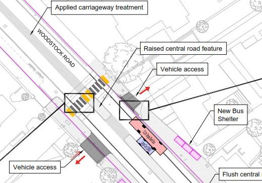 There is then a list of proposals and a useful PDF that shows them in a more graphical form if, like me, you respond better to pictures than words! Here are the proposals:
Widening the footways where possible to improve pedestrian movements within the area.
- Narrow the carriageway running lanes to 3.0m, this will help in encouraging lower vehicle speeds and reduce the crossing distance for pedestrians. To reduce the speed of approaching traffic this principle will be extended north to Observatory Street by applying a road surface treatment along the centreline.
- Maintain the existing 1.5m mandatory cycle lanes in both directions but replace the standard carriageway marking with a double row of cleft (rough) engineered granite setts 20mm high with tapered edges to discourage motorists from inadvertently entering the cycle lane.
- Use low height kerbs (50mm) within the general area to assist pedestrians when crossing especially for people with mobility problems with the exception of the bus stops which will have 120mm high kerbs to facilitate boarding and alighting.
- Relocate the southbound bus stop slightly further north to a wider area of footway and provide a new style shelter with improved visibility of approaching buses, capable of being fitted with RTI.
- Provide a flush central feature to act as a pedestrian refuge, similar to that used on Oxford High Street. This will allow pedestrians to cross an individual lane of traffic approaching from one direction at a time then wait in the central area before completing the crossing movement.
- Provide courtesy style crossings at the northern and southern limits to coincide with the link routes to Walton Street. This style of crossing has already been successfully used within Oxford Railway Station, Corn Street in Witney and Thame High Street. These flat topped humps will highlight pedestrian priority and will also be inlayed with engineered granite setts to give the appearance of a zebra crossing but without the need to provide unsightly zig-zag markings and flashing belisha beacons.
- The inclusion of enhanced crossing points will result in the loss of some on-street parking; all but four spaces will be re-located to the northern end of the scheme.
- The scheme will be sympathetic to the historical context of the adjacent buildings with improved paving, granite chippings in the road surface and reduced street clutter.
I’m very interested to hear people’s view on this so please do let me know what you think. Once the consultation is officially open I’ll add the official consultation response details. I should also remind you that under the Local Government (Access to Information) Act 1985 the Council is obliged to make any representations received in formal response open to public inspection. Please do go ahead and comment on this post – those comments will be public anyway but do not form part of the official consultation responses.
Vehicles entering the vehicle access route opposite the Infirmary (adjacent to the current brick bus shelter) need to take the turn very wide because of the narrow gap between the buildings. This doesn’t seem to have been allowed for with the ‘central road feature’. Making the turn (in or out) is a challenge in a big car such as the one owned by IT Services.
Placing a pedestrian crossing so close to what is already a blind exit will add more pedestrians on a piece of pavement where emerging vehicles can’t see them.
It would be safer to increase the width of pavement than have a central reservation, at least for this part of the road.